R500 RTK
R500 RTK
Surveying and Mapping UAV
Integrated Carbon Fiber Fuselage
Network RTK
12 KM Max Transmission
6K 25 FPS Video
60-min Max Flight Time
IP54 Rating

6k ultra hight definition aerial camera
Support shooting 6 25fps, 4K 30fps/60fps video and 21 million pixel photos, support H.265 encoding format output, retain the most true details, 85° ultra-low distortion rate wide Angle lens, let your creation more inspiration.
Born for aerial survey
R500 is a small, multi-rotor, high-precision aerial survey uav for low-altitude photogram-metry applications. Equipped with centimeter-level navigation and positioning system and high-performance imaging system, it is portable and easy to use to comprehensively improve the efficiency of aerial survey.
Efficiency
The efficiency of UAV field data acquisition is about 5 to 10 times that of traditional manual operation.
Cost reduction
Low cost of equipment, simple operation,
highly automated operation to reduce.
Diversity of surveying and mapping results
Provide DOM, DSM and other mapping results to meet
avariety of needs.
12 KM Transmission
R500 RTK UAV adopts 2.4G long-distance transmission system, which can transmit the maximum map distance up to 12km.
Network RTK (optional)
Integrated new RTK module, with strong anti-magnetic interference capability and accurate positioning capability, providing real-time centimeter-level positioning data.
60 minutes flight time
Lightweight integrated carbon fiber fuselage design, the fuselage is strong earthquake resistance; Equipped with 7000mAh large-capacity intelligent battery, the maximum continuous flight time is up to 60 minutes (no-load state, hovering flight in the state of no wind at sea level).
Intelligent environment awareness

With the WKRC-H12 screen remote control
With Android embedded system, advanced SDR technology and super protocol stack the image s clearer, the delay is lower, the distance is longer and the anti-interference is stronger.

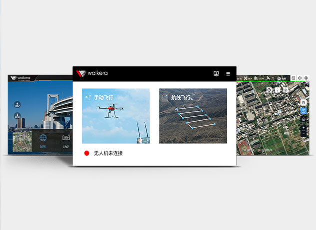
Application software
Inview of different requirements of aerial photo-graphy applications, we developed a special R500 APP with a simple operation interface and easy operation.
Technical Specifications
| Symmetrical motor wheelbase | 460mm |
| Body size | 367mm*367mm*228mm |
| electric machinery | KV value 650rpm/V |
| Electric regulation | Continuous current 45A |
| Propeller specifications | Diameter * pitch: 11 * 4.5 inch |
| Normal takeoff weight | 1.38kg (including battery and PTZ) |
| Maximum takeoff weight | 2.0kg |
| Ascending speed | Factory default 5 m/s, (3~8m/s adjustable) |
| Descending speed | Factory default 3 m/s, (3~8m/s adjustable) |
| Horizontal flight speed | GPS mode: 5m/s; Motion mode: factory default 10m/s (5~20m/s adjustable); Attitude mode: 15m/s (windless environment) |
| Maximum tilt angle | GPS mode: 25 °; Motion mode: 30 °; Attitude mode: 30 °; |
| Maximum rotation angular velocity | 150°/s |
| Maximum flight altitude | 4500m |
| Maximum tolerable wind speed | 17m/s |
| Maximum endurance | 60 minutes (no load, no camera PTZ attached); 50 minutes (mount the camera PTZ); |
| Operating ambient temperature | -10 ℃ to+40 ℃ |
| positioning accuracy | GPS: vertical ± 1.5 m, horizontal ± 0.4 m (GPS positioning works normally) |
| Cooperate with network RTK | Horizontal 1cm+1ppm, vertical 2cm+1ppm (GPS positioning works normally, network RTK connection works normally) |
| Obstacle perception range | 12m |
| FOV | Horizontal 30 °, vertical ± 2.4 ° |
| Measuring frequency | 100 Hz |
| Height measurement range | ≤ 12 m |
| Precise hover range | ±0.1m |
| Measuring frequency | 100Hz |
| model | WKRC-H12 |
| working frequency | 2400MHz to 2483MHz |
| Maximum communication distance | 12Km (open without shelter and electromagnetic interference) |
| Display device | 5.5 inch 1920 * 1080 1000NITS highlight display |
| Charging interface | TYPE-C |
| Battery | 3.7V 10000mAh LiPo 1S |
| Operating ambient temperature | -10 ℃ to 40 ℃ |
| Charging ambient temperature | 5 ℃ to 40 ℃ |
| weight | 530g |
| size | 190*152*94mm |
| Use frequency band | GPS: L1 /L2/L5 GLONASS:F1/F2; BeiDou: B1/B2/B3 Galileo:E1/E5 |
| positioning accuracy | Horizontal: 1cm+1ppm Vertical: 2cm+1ppm; 1ppm: the accuracy will change by 1mm for every 1km increase. |
| Positioning update rate | 1000HZ |
| cold boot | <45s |
| Hot start | <10s |
| Recapture | <1s |
| Initialization Reliability | >99.9% |
| Differential data transmission format | RTCM 2.X/3.X |
| data link | 4G |
| Communication distance | Unlimited distance (with 4G network signal) |
| Operating ambient temperature | 10 ℃ to 45 ℃ |
| Image sensor | 1-inch SONY back illuminated CMOS |
| camera lens | FOV85°; Equivalent 9mm focal length; F/3.5 Aperture |
| photograph | 21 megapixel support |
| video recording | 6K (5480*3648) @25fps; 4K (3860*2160) @25fps/30fps/60fps |
| Zoom | 25x lossless digital zoom |
| video coding | H264、H265 |
| Supports file system formats | exfat |
| Video format | MP4 |
| Picture Format | JPG |
| Supported memory card types | Micro SD card, which supports 512G at most and has a transmission speed of Class10 or above or reaches UHS-1 rating |
| Voltage | 22.2V |
| capacity | 7000mAh |
| Battery type | LiPo 6S |
| energy | 155.4Wh |
| Charging ambient temperature | 5 ℃ to 40 ℃ |


